
As hinted at in my last trip report, I decided the Limmers were ready to try some climbing so it was time to find a mountain. The views of Carrigain had reminded me of how much I’d enjoyed my first trip up the Desolation Trail. I found a few days I could go AWOL and loaded up the scoot. The snow was all gone at lower elevations and I had an uneventful first day’s hike out to the Stillwater area.
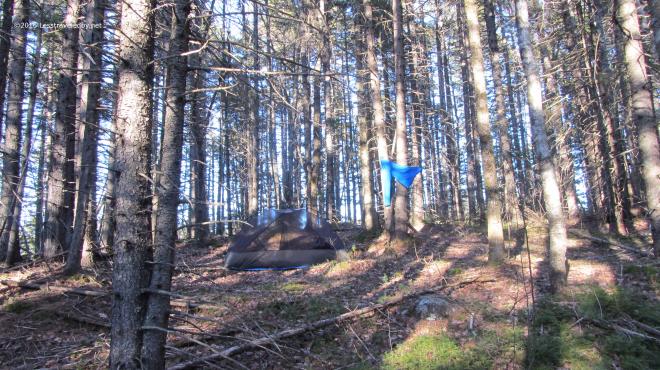 I camped on the same knob above the river as last time, but with the snow melted it looked a very different place. The established ad hoc site was clearly visible with its rarely used fire ring and frequently used sitting log. LNT says use what you find so I set up there and then spent a while trying to find the spot I’d camped on the last trip. I finally found it the next morning on my way out by recognizing the little tree that took a bite out of my Patagucci pants, but there was no trace that anyone had camped there.
 The late afternoon sun was lingering later just a few weeks further into Spring and certainly appreciated. The bug house was up, but only a few random flies were around. Later I would put the roof on to keep a chilly breeze out as the night dipped into the 20s. I brought both quilts along which was overkill, but very snuggly that night.
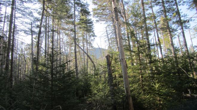 In the morning it was time to go find that mountain. Passing through the new growth of the Stillwater area there were occasional glimpses of Carrigain waiting for me up ahead. The trail through here is all very flat right up until you start the actual climb which I find amusing. It sort of sneaks up on you and then you find yourself on the mountain.
 Well, I guess there is some warning. The name of this trail has always appealed to me, long before I dared to think about climbing it. I recall wishing I was the sort of person who could do that but the elevation profile scared the heck out of me. Now here I was coming back to use this climb to test out how well my boots were breaking in.
 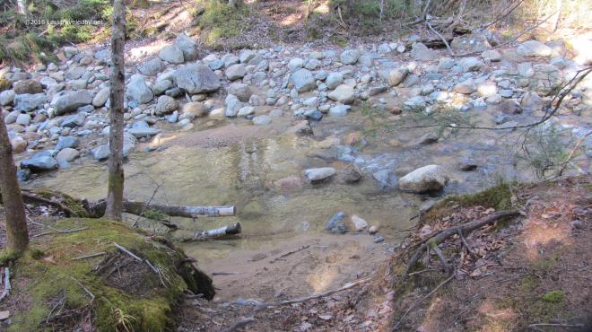 The crossing at the base of the mountain was really low for early May. I like easy crossings, but I’m a bit concerned about how dry this year is going to be. My plans have me traveling mostly to other areas this year so I’ll have to keep an eye on other folks trip reports to know how water supplies are holding up since I won’t be seeing the Pemi nearly as much this year as last.
 Then it was time to head up. For most of the climb there are views of the Vose Spur off to the east which I like to use to gauge my progress. I know it stands a bit lower than where I’m headed so as long as it is above me I shouldn’t get my hopes up I’m almost done.
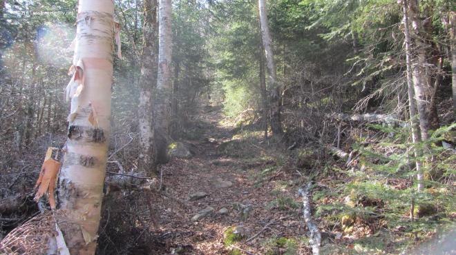 The first thousand feet or so of climbing was done on relatively dry trail. It was a nice cool morning which is my favorite for going up mountains and I was really enjoying the day.
 If you are going to go to all the trouble of climbing mountains it should be on a day with views like this. There was a little haze, not perfect, but Washington in the distance looked pretty clear to me.
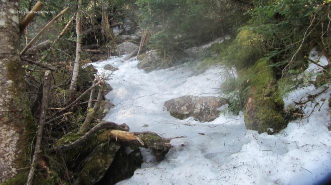 Then I hit the ice! There are no more pictures of the climb because I was too busy to look anywhere but my feet. So long as the trail has some flat spots walking on ice isn’t that hard provided you have your spikes on. It was the more vertical sections that posed the real challenge. Even without ice there are some really steep sections that make you work for every foot of gain on this trail. With the ice there were a few spots that scared the crap out of me heh. At one point I became stuck on the middle of a section that seemed more wall than floor and found myself wishing for an ice axe. After carefully sliding down about twenty feet I stopped on a ledge and found a different route up. This was, at least as far as I’m concerned, some pretty serious stuff.
Then, just as I was approaching the summit, I met a man coming down towards me with just a pair of low hiking shoes on his feet. Despite my encouragement to reconsider, he said he’d probably be OK and continued on. No traction, no satcom and over a mile of serious ice ahead of him on a trail that wouldn’t likely see another hiker for a week or more, I wished him luck and meant it. I think I saw his footprints at the base of the mountain the next day, at least I hoped so.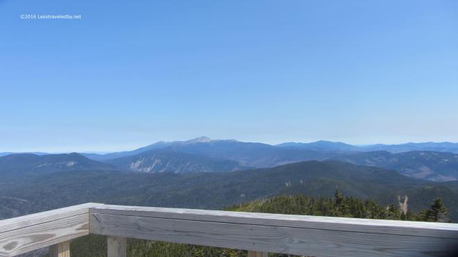 The summit was of course worth the effort. Despite my dislike of climbing towers I raced right up to the top this time. With a seriously chilly breeze blowing up there I didn’t stay long. Not much winter snow left on the high peaks, but I bet there is still plenty of ice up there.
 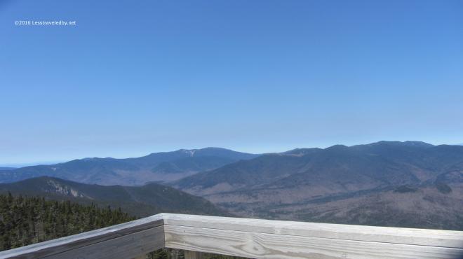 I love this perspective looking back over most of the Pemi from the top of Carrigain. So often I am somewhere else out there looking at this peak, I’ve even spotted the tower from the Bonds. I’m going to miss this place this Summer. Last year allowed me to really explore this place, but other trails are calling.
 Never having seen the other side of the mountain I’d planned this trip as a loop so I could do some exploring outside the wilderness before turning around and heading back in. The view looking back up at the tower as I descended Signal Ridge shows this side is pretty steep too, but the trail was much easier with switchbacks easing some of the vertical. There was still some serious ice and I had to put my spikes back on several times.
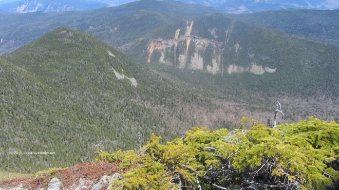 Looking down from the ridge I could see the notch far below. After descending to my right I’d be heading back to my left climbing up that notch. Seemed like a lot of work still to be done, but I comforted myself with the thought that I’d finally redline that missing mile or so of Pemi trail I needed on the Carrigain Notch Trail.
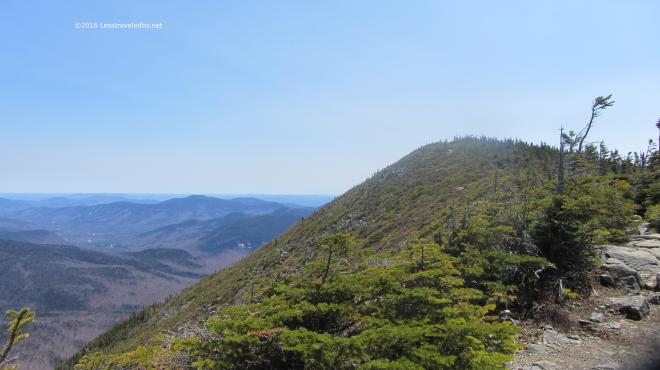 Besides it was a beautiful day for a hike and I was on virgin trail I’d never trampled before. So I’d hike down only to go back up. What else is new?
 These fancy signs make it clear we’re not in the wilderness anymore. Wide groomed trails with clear signage are nice, but I was glad to be headed back into the Pemi rather than out to the highway with the day hikers. Sorry to say the camera crapped out on me at this point so no more pictures. Thinking I may need a new trail camera, but if you’ve ever shopped for photography equipment you know the dilemma of deciding between spending too much money or buying cheap crap. If you’ve found a good middle ground solution I’d love to hear about it.
Anyway, I toddled up the notch as the afternoon wore on. It was a bit of a climb, but never very rugged and then a bit swampy on the way down to the Nancy Pond trail. I set up for the night on this side of Stillwater and headed out the next day. Then it was time to spend a few weeks landscaping the front yard. I guess that is one way to keep in shape between hikes and I’ll be spending plenty of time out on trail soon!
Technical Info:
The map and profile below cover the day of the climb only. I ended up running low on light so camped short of Stillwater the second night rather than back where I’d started the day; A difference of about a mile.
 The actual climb is about 2500′ via the Desolation Trail and the good or bad news is it is only about 2 miles to the top, depending on how you feel about climbing.
 Not sure the .gpx matched up correctly with the satellite picture in this image, but it gives you an idea of the route at least. Travel was counter clockwise around the loop. You’ll want to bring a real map with you if you go rather than relying on this 🙂
